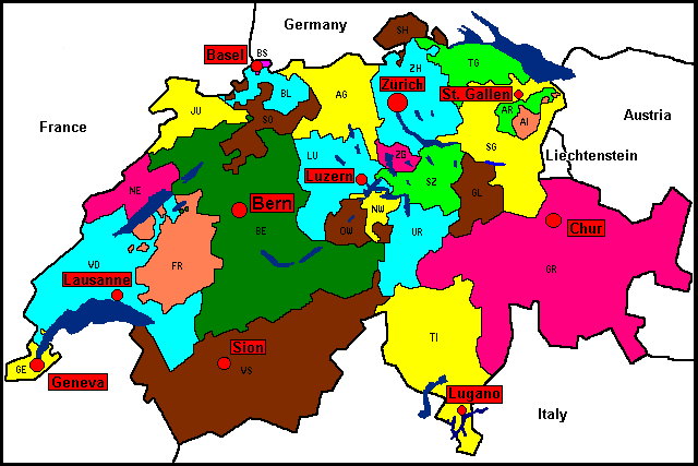
Northeast Switzerland
The Story of Wigoltingen
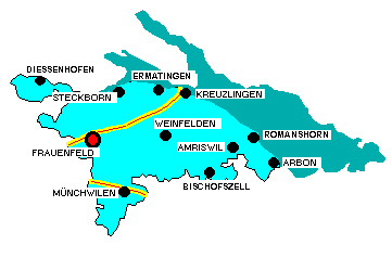
Wigoltingen lies halfway between Weinfelden and Frauenfeld in the valley of the Thur. All three of these towns within a radius of ten miles served as homes of the Spiri family at one time or another.
 These places are very near the shores of Lake Constance, which is on the border between Switzerland and Germany. From here are seen distant views of the Zurich uplands and Morsburg Castle at Winterthur to the west. To the south through a flat valley flows the Thur and beyond are the heights of Gabris and Rigi. Weinfelden lies to the east of Wigoltingen and southwest can be seen the vine-covered Ottoberg hill and the town of Ottoberg surrounded by orchards. Twenty-two church towers can be counted from the minister's parsonage in Wigoltingen gleaming among the valleys and hills and on the fruitful terraces of the lake ridges. To crown the view rise the stone cliffs and majestic spires of the Santis Mountains in the Canton Appenzell to the south. They rise to a height of about 9000 feet and are the foothills of the Alps. All of Canton Thurgau presents this rolling landscape of farms, orchards and vineyards and here and there nestled gristmills, which seemed especially to interest the Spiris.
 Both Spiris and Freienmuths were known in the community of Wigoltingen since 1597. The Spiris (or Spiry) came originally from Jungholtz. These names were found in the marriage register that marks the fist appearance of some of these names. Freienmuth was also spelled with a Y then, or Freyenmuth.
If you have questions about any of the information found here, please contact me.